
3 rivers merge into striking half-and-half waterway in Guyana — Earth from space
Understand this faster with AI


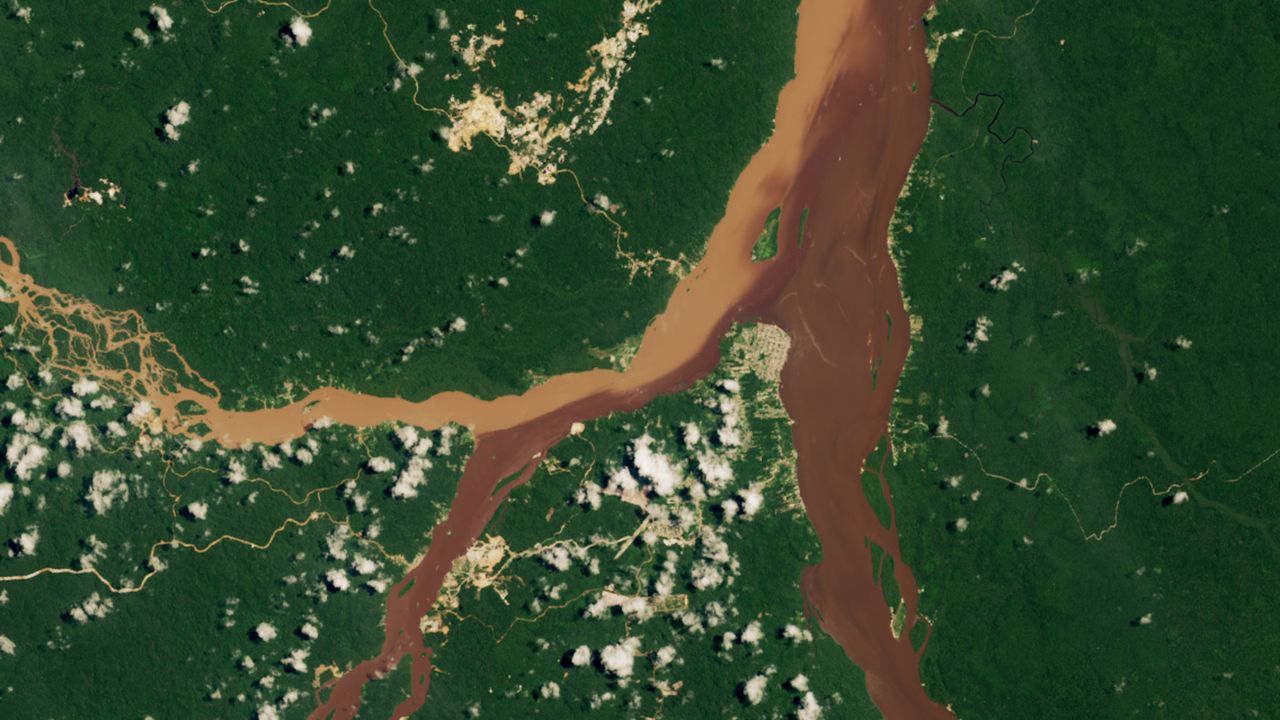
A 2023 satellite photo highlights the point where a trio of rivers converges in Guyana. One of the waterways has been significantly altered by mining waste, creating a striking color contrast. When you purchase through links on our site, we may earn an affiliate commission. Here’s how it works. Get the world’s most fascinating discoveries delivered straight to your inbox.Become a Member in Seconds Unlock instant access to exclusive member features.You are now subscribedYour newsletter sign-up was successfulWant to add more newsletters?Delivered DailyDaily NewsletterSign up for the latest discoveries, groundbreaking research and fascinating breakthroughs that impact you and the wider world direct to your inbox.Once a weekLife's Little MysteriesFeed your curiosity with an exclusive mystery every week, solved with science and delivered direct to your inbox before it's seen anywhere else.Once a weekHow It WorksSign up to our free science & technology newsletter for your weekly fix of fascinating articles, quick quizzes, amazing images, and moreDelivered dailySpace.com NewsletterBreaking space news, the latest updates on rocket launches, skywatching events and more!Once a monthWatch This SpaceSign up to our monthly entertainment newsletter to keep up with all our coverage of the latest sci-fi and space movies, tv shows, games and books.Once a weekNight Sky This WeekDiscover this week's must-see night sky events, moon phases, and stunning astrophotos. Sign up for our skywatching newsletter and explore the universe with us!Join the clubGet full access to premium articles, exclusive features and a growing list of member rewards.Where is it? Bartica, Guyana [6.4073096658, -58.62373473]What's in the photo? A trio of waterways merging into a striking "half-and-half" riverWhich satellite took the photo? Landsat 8When was it taken? Aug. 16, 2023This striking satellite photo shows off the contrasting colors at the point where three rivers converge in Guyana. The multicolor waterways result from the country's unique geology, as well as an increasingly disruptive human-caused factor.In the Indigenous Arawak language, Guyana means "land of many waters," which is an apt name, given that the country is home to 10 major rivers and dozens of smaller waterways, despite being around the size of South Carolina, according to NASA's Earth Observatory.This unique hydrology is linked to the Guiana Shield, a 1.7 billion-year-old geologic feature that covers Guyana as well as parts of Venezuela, Brazil, Suriname and French Guiana. The shield contains hard crystalline bedrock made up of rocks such as gneiss and granite, meaning it does not easily erode except from flowing water, which has carved out many routes through the region.In this photo, two smaller rivers — the Cuyuni River (left) and the Mazaruni River (center left) — come together shortly before merging with the Essequibo River (center right) to form one of Guyana's largest waterways.The town of Bartica, which is home to around 15,000 people, is located on the piece of land that juts into the water at the point of the secondary merger. From there, the enlarged Essequibo River flows northward for around 30 miles (50 kilometers), before draining into the Atlantic Ocean. Prior to merging, the Mazaruni and Essequibo are dark brown, which is likely the result of tannins — chemicals released by rotting vegetation that stain waterways via a process similar to tea brewing. The Cuyuni is light brown due to high levels of suspended sediment in its water, according to the Earth Observatory.When the rivers meet, the lighter and darker waters do not readily mix because of the differences in density caused by varying levels of sediment.Get the world’s most fascinating discoveries delivered straight to your inbox.While the presence of tannins is a natural phenomenon triggered by flooding, the high levels of sediment are the result of mining waste that is dumped in the Mazaruni."This image is from a wet time of year when all three rivers were running high and carrying a lot of sediment," Evan Dethier, a hydrologist at Colby College in Maine, told the Earth Observatory. "But the Cuyuni is the clear outlier, which we can attribute to the intensity of mining upstream."Guyana is a hotspot for mining, largely because of its vast deposits of gold, diamonds and bauxite, as well as lithium, copper and nickel, which are also linked to the Guiana Shield, according to the U.S. Department of Commerce. The country's mining industry began in ernest in the mid-2000s, and since then, the concentration of sediment in the Cuyuni has likely increased tenfold, Dethier said. Similar changes have been documented in rivers across the planet.A 2022 study led by Dethier revealed that sediment concendrations in rivers in the Southern Hemisphere has risen by around 40%, largely due to mining and deforestation. However, the opposite is true in the Northern Hemisphere due to the construction of large-scale dams, which have blocked sediment flow by around half.The changes in global sediment flow also may be affecting the marine environment, because the sediment input in most of the world's oceans has changed drastically, the study warned — but it is still too soon to see what sort of long-term effect this may have. Tibet's shapeshifting 'braided river'A 2025 satellite photo shows a particularly complex section of the Yarlung Zangbo River as it twists its way through the Tibetan Plateau. 'Golden dragon' river in AlabamaA 2023 astronaut photo shows the moment the Alabama River briefly morphed into an undulating golden serpent, similar in shape to a Chinese dragon. Green River winds through 'shadows'A 2018 astronaut photo shows a striking section of the Green River as it winds through Utah's "Labyrinth Canyon." Harry is a U.K.-based senior staff writer at Live Science. He studied marine biology at the University of Exeter before training to become a journalist. He covers a wide range of topics including space exploration, planetary science, space weather, climate change, animal behavior and paleontology. His recent work on the solar maximum won "best space submission" at the 2024 Aerospace Media Awards and was shortlisted in the "top scoop" category at the NCTJ Awards for Excellence in 2023. He also writes Live Science's weekly Earth from space series. You must confirm your public display name before commentingPlease logout and then login again, you will then be prompted to enter your display name.
Tags
Source Information
Discussion
0 professional contributions
Sign in to join this professional discussion.
Be the first to add a constructive contribution.